

The fundamental nature of Earth Satellite Orbits
There have been a few exceptions to the LEO satellites for amateurs. For instance, OSCAR-9, 10, and 13 were phase-3 satellite originally designated as P3A, P3B, and P3C respectively. They were meant to operate in a highly elliptical orbit with a high apogee to perigee ratio. Typically the apogee was planned to be around 36000 Km with the perigee around 2500-4000 Km. OSCAR-9 suffered a launch failure while OSCAR-10 was a partial success. OSCAR-13 did indeed serve us well and was operational till 1996. In the year 2000, the P3D OSCAR-40 was launched. It was a heavy advanced satellite with an apogee of 59258 Km but unfortunately, it failed in the year 2003. The next phase-3 satellite P3E is awaiting launch at this time. All these were efforts of AMSAT-DL (Germany) in association with AMSAT-NA.
Currently, radio amateurs also have access to a phase-4 transponder on a Geostationary satellite Es’hail-2 (QO-100) parked over the equator and placed over Africa at 25.9° East longitude to provide simultaneous coverage across entire Africa, Europe, and large parts of Asia. It works in the S-band/X-band microwave bands. This has ushered amateur radio into the realm of geostationary satellites.
Long before artificial earth satellites came into vogue, radio amateurs were experimenting with communication using the one and only earth’s natural satellite, the moon. The moon is a large passive satellite revolving around the earth, its surface was used since the early 1960s (and still is) to bounce signals off its surface for establishing communication between two distant radio stations on earth. This is called Moonbounce or EME communication. Check out more on this in our article titles EME Moonbounce Communication.
One might ask at this stage, why do I need to know all this? Can’t I just use satellite tracking software to determine the next pass and point my hand-held Yagi connected to my HT and work via the satellite? … Yeah! Sure you can. However, you would be missing out on most of the best things that amateur satellite radio has to offer. Just working via a few LEO FM repeater satellites occasionally under the cited conditions is only the tip of the iceberg when it comes to satellite radio communication. This type of operation is termed as Easy-Sat operation. Understanding Orbit characteristics, space radio propagation, etc will open up new vistas leading to a whole new world of activities that you might have been missing.
Important Attributes Related to Earth Satellite Orbits
The orbits of satellites revolving around the earth are of many types with their own distinct flavors. Various kinds of earth satellite orbits provide us with different types of communication coverage as desired on a case-to-case basis. Our ability to place satellites in different types of orbits around earth gives us the necessary leverage. Every pre-planned and pre-designated earth satellite orbit is governed by several orbital attributes and parameters. Let us take a quick look at some of the more important ones that would eventually allow us to understand their orbital patterns and consequently their geographic reach capabilities.
As we mentioned earlier, the earth satellites may be placed in orbits that may be around the equatorial plane or maybe at various angles of inclination with respect to the equator. Some of the inclined orbits may be shallow while others may be quite steep nearing almost 90° (orthogonal) to the equator. Some may be placed in such a way that they always face the sun and never go into the shadow zone. They may also be placed at different altitudes above the earth resulting in different time periods of orbit. Some of these earth satellite orbits may be geometrically circular in shape while many others may deliberately be placed in elliptical-shaped orbits. The degree of elliptical eccentricity may vary among satellites. Moreover, some earth satellite orbits may be made to progress along the direction of the earth’s rotation from west to east, while others may be placed with inclination angles so that they move in the opposite direction.
With so many factors to consider while dealing with satellites, let us briefly examine and try to make a sense of the above-cited attributes…
MEO Satellites – These are Medium Earth Orbit satellites that usually have orbital altitude above earth’s surface in the range of 2000-35000 Km. They feature longer time periods of orbital rotation and typically offer a larger communication area coverage on earth. However, amateur radio satellites rarely fall into this category.

Depiction of a typical Geostationary orbit around the earth in an equatorial plane.
This brings us to a special case, called the Geostationary satellite. This is the special case where the orbital inclination (w.r.t. earth’s equatorial plane) is carefully made equal to zero. As a result of which the gradually north-south drift of a general geosynchronous satellite we noticed earlier on account of its inclination is no more there. A Geostationary satellite always appears to be at a fixed place in the sky at its designated placement longitude and right above the equator (0° latitude). These satellites are best suited for DBS (DTH) services for bringing satellite TV to our homes. The azimuth and elevation angles of dish antennas at our homes, once oriented properly, need not be changed ever again.
Apogee – This is valid only when the orbit is elliptical and designates the furthest point of the orbit from the earth.
Perigee – This is also an attribute of an elliptical orbit. The perigee designated the closest point to the earth of an elliptical orbit.
Inclination – This is the parameter that specifies the orbital inclination of the earth’s satellite orbit w.r.t. the equator. It is measured by measuring the angle between the equatorial plane and the orbital plane of the satellite.
Eccentricity – This parameter determines the nature of the earth’s satellite orbit in terms of whether it is a circular orbit (eccentricity = 0) or an elliptical orbit. In the case of an elliptical orbit, the magnitude of the eccentricity parameter determines how close to earth will the satellite be during its nearest point at perigee during a pass and also how far it will be away during apogee. The eccentricity value is always between 0 and 1. Any fraction greater than 0 but less than 1 designates the eccentricity of the earth’s satellite orbit. However, eccentricity equal to 1 is a limiting value and is not possible for a practical elliptical orbit. This could only happen if the orbit were to be a parabola.
Period — The time required for a satellite to make one complete revolution about the Earth. The concepts of the Anomalistic period and the Nodal period further define it but let us ignore these for the time being…
Satellite Pass — Segment of orbit during which the satellite passes nearby and in range of a particular ground station.
Prograde Orbit – A satellite orbit which has an inclination between 0-90° is a Prograde orbit. The effective direction of satellite motion is in the direction of rotation of the parent body (Earth).
Retrograde Orbit – A satellite orbit which has an inclination between 90-180° is a Retrograde orbit. The effective direction of satellite motion is in the direction opposite to the rotation of the parent body (Earth).
Sub-Satellite Point (SSP) – Subsatellite point. A point on the surface of the Earth directly between the satellite and the geo-center.
Assending Node – The point on the ground track of the satellite orbit where the sub-satellite point (SSP) crosses the equator from the Southern Hemisphere into the Northern Hemisphere.
Desending Node – The point on the ground track of the satellite orbit where the sub-satellite point (SSP) crosses the equator from the Northern Hemisphere into the Southern Hemisphere.
AOS (Acquisition of Signal) – This is the moment when the satellite comes into range and can be accessed. The easiest way to know you have achieved AOS it to listen for the beacons on the satellites that have them. This parameter is the opposite of LOS.
LOS (Loss of Signal) – The moment at the fag-end of the pass when the satellite can no longer be heard.
Keplerian Elements — The classical set of six orbital element numbers used to define and compute satellite orbital motions. The set is comprised of inclination, Right Ascension of Ascending Node (RAAN), eccentricity, the argument of perigee, mean anomaly, and mean motion, all specified at a particular epoch or reference year, day, and time. Additionally, a decay rate or drag factor is usually included to refine the computation.
Epoch — The reference time at which a particular set of parameters describing satellite motion (Keplerian elements) are defined.
Right Ascension of Ascending Node (RAAN) – The Keplerian element specifies the angular distance, measured eastward along the celestial equator, between the vernal equinox and the hour circle of the ascending node of a satellite. This can be simplified to mean roughly the longitude of the ascending node.
Visibility Circle (Footprint) — The range of area on the Earth that is seen by a satellite. This is also called the “footprint” for that satellite.
Mean Motion – The number of orbits per solar day (86,400 sec or 24 hours), based on assumed two-body motion.
Solar Day — The solar day, by definition, contains exactly 24 hours (1440 minutes). During the solar day the Earth rotates slightly more than 360° about its axis with respect to fixed stars (see Sidereal day).
Sidereal Day — The amount of time required for the Earth to rotate exactly 360° about its axis with respect to the fixed stars. The sidereal day contains 1436.07 minutes (see Solar day).
Spin Modulation — Periodic amplitude fade-and-peak resulting from the rotation of a satellite’s antennas about its spin axis, rotating the antenna peaks and nulls.
Though there are many other parameters that are used to precisely define finer aspects of orbital motion, the above-cited parameters defining various important attributes of satellites orbits are usually more than enough for regular amateur radio purposes. In the following section, let us focus on various other important factors specifically related to LEO satellites for amateur radio use.
LEO Satellites for Amateur Radio Service
The Low Earth Orbit (LEO) satellites for amateur radio have evolved through what we term as Phase-1 and Phase-2 type satellites. The earliest ones in the late 1960s only had a battery as the power source. They had no solar panels for replenishing the battery charge. They were the phase-1 satellites. But that is ancient history. Most amateur radio satellites launched from 1970 onwards were phase-2 satellites with the ability to recharge batteries from solar energy when the orbital pass would face the sun. These phase-2 satellites are capable of providing many years of service.
The phase-3, phase-4, and the planned phase-5 amateur radio satellites are quite different have distinctive orbital characteristics.
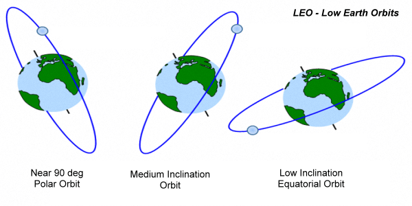
Typical degrees of inclination of LEO earth orbit satellites.
Nano-Satellites (Nanosat) and Cubesats
Usually, the smaller satellites of the Nano-satellite varieties are very lightweight, have low TX power output, simple onboard antennas, usually cubical shaped, or its variant with surface embedded solar panels. They normally have no attitude stabilization whatsoever. They freely, roll, yaw, pitch, and tumble around as they travel along their orbital path. Nano-satellites range in weight from 1-10 Kg.CubeSats are a subset of Nanosats which follow a standardized shape in terms of physical form-factor. Cubesats are made in various sizes but the dimensions are multiples of a standard designated Unit Cube size. A Unit cube is a 10x10x10 Cm cube. In a Cubesat design, several unit cubes may be stacked together in various arrangements to obtain a larger size, however, the longest dimension is rarely more than 30 Cm.
These Nanosats and Cubesats are usually placed in LEO orbits at lower altitudes compared to larger satellites that output more TX power and carry better antennas. A typical Nanosat is placed in a polar orbit and carries a telemetry beacon and low power cross-band FM repeater for amateur use. Due to their lower orbital; altitudes they typically have a shorter radius of coverage on earth.

Illustration depicting the variation of orbital periods of satellites depending on their altitudes.
Micro-Satellites and Mini-Satellites
The satellites weighing between 10-100 Kg are called Micro-satellites, while those weighing between 100-1000 Kg are called Mini-satellites. Barring the Nanosat variety, most of the amateur radio phase-2 satellites fall in the Microsat class. However, phase-3 satellites were microsats.Amateur radio LEO satellites in the Microsat class usually have far greater features and capabilities compared to Nanosats. These satellites are the mainstay of amateur satellite communication. They orbit at higher altitudes thus producing a larger signal illumination footprint on the ground. This allows longer coverage ranges between distant stations on earth. Due to greater satellite distance from the ground stations, they produce greater propagation path losses requiring proportionately more TX power output at both ends as well as a better and higher gain antenna at the ground station to effectively leverage DX coverage by acquiring the satellite at low elevation angles and as close above the horizon as possible.
Most of the Microsats have better and more efficient onboard antennas and larger batteries providing more electric power to electrical systems on the satellite. Larger solar panels or solar sails allow more electric energy to be generated.
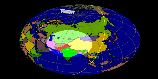
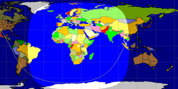
A typical low altitude FM Repeater type LEO satellite AO-91 pass depicting a footprint that is smaller in radius and hence a smaller covered region.
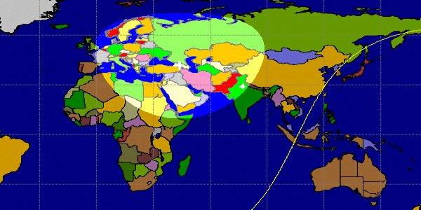
A typical higher altitude Linear Transponder type LEO satellite Fuji FO-29 (JAS-2) pass depicting a footprint that is larger in radius and hence a larger covered region.
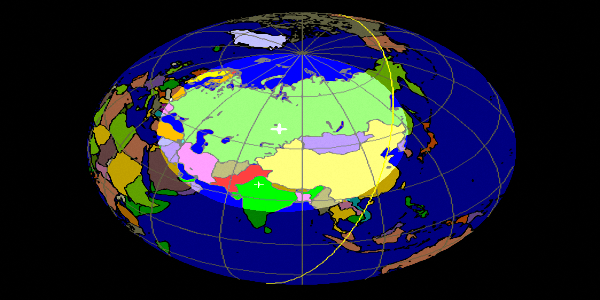
A typical higher altitude Linear Transponder type LEO satellite AO-7 pass depicting a footprint that is larger in radius and hence a larger covered region.
LEO Satellite Polar & Sun-Synchronous Orbits
All LEO communication satellites are placed in orbits that are usually (nearly) circular at low altitudes as we discussed earlier. These satellites have various inclinations w.r.t. the equator and their obit periods are typically around 90 minutes, however, some may have periods up to about 120 minutes depending on their altitudes.
Polar Orbits
LEO orbits may be classified in several ways. The most common method is to classify them by their orbital inclinations and some other unique orbit properties. The LEO satellites that have orbital inclination between 60-120° are usually termed Polar satellites. Please note that the inclination of less than 90° qualifies it as a Prograde orbit meaning that their direction of progression of the movement is along the direction of the rotation of the earth, whereas, the earth satellites that have inclinations greater than 90° tend to have orbital progression in the opposite direction from east to west.Medium and Low Inclination LEO Orbits
Although most of the amateur radio earth satellite orbits are polar orbits, there are some instances of satellites being placed with lower orbital inclinations, especially when they are intended to focus coverage only at mid-latitudes or the tropical region.A classic example is the International Space Station (ISS) which is quite popular among radio amateurs. It has an inclination of 51.645° and a nominal altitude of 400 km above the earth’s surface. The orbit period is 92.88 minutes. The astronauts onboard the ISS often carry out QSO with radio amateurs on earth.
A few other satellites like the LAPAN-A2 (IO-86) are typical examples of very low inclination satellites. Its inclination is only 6.00°. It is a multi-purpose microsat that also has an FM repeater with 2m uplink and 70cm downlink. Due to its extremely low inclination, the LAPAN-A2 is not accessible at most locations around the world except for a narrow belt in the equatorial region.
Sun-Synchronous LEO Satellite Orbits

An animation showing a typical orbital trajectory of a LEO sun-synchronous satellite.
However, if the orbital altitude and the inclination were to be planned in such a way that the total number of satellite orbits in a 24-hour solar day window was to be an exact integral multiple, then on each subsequent day the satellite will tend to appear over any location on earth at the same time as the previous day. This makes the satellite orbit Synchronous in a way… Is this what we call Sun-synchronous?… No, there is more to it than just this. The earth also revolves around the sun. Hence, for the orbital pass to be truly fixed in time day-after-day through all seasons round the year, we need to compensate the orbit orientation to account for a 360° of additional shift that it needs to undergo over the full year(365 days). This is where the fun begins.
To make the above-cited orbit truly Sun-synchronous, we need to somehow factor in the effect of earth’s revolution around the sun. How is it done?… Well, based on the earth’s shape and gravitational properties, a clever method was devised. We need to recognize that the earth is not perfectly spherical but it is slightly flattened at the poles and has a bulge at the equator. This is known as Oblateness of the earth and the earth is termed as Oblate shaped. Hence, the gravitational vectors in 3D all around the earth are not constant. The acceleration due to gravity (G) as experienced by the orbiting satellite while passing over various locations above eath constantly vary.
The above-cited effect creates an additional force vector that acts on the satellite orbit. This makes the otherwise expected fixed orbital plane of the satellite to start deviating. The inclined orbital plane begins to shift its orientation around the earth’s geographic axis. This movement of the satellite orbital plane is called Precession. The rate of precession may vary from almost zero to several degrees per day. As a consequence, the orbital plane itself orbits (precesses) around the axis of the earth at a slow rate.
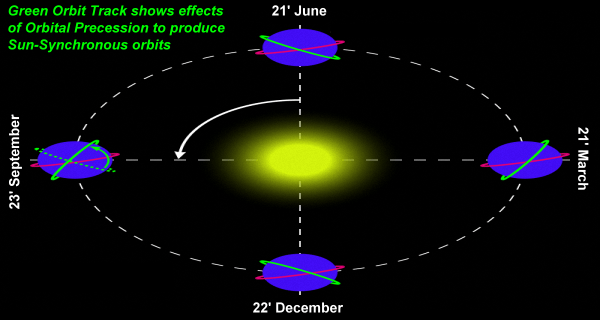
The effect of orbital plane precession resulting in perfect sun-synchronous orbit that continuously aligns its orbital plane to account for the revolution of earth around the sun.
The earth revolves around the sun in 365 days completing 360° angular movement. Therefore, each day the angular shift if 360/365 = 0.986°. Now, if we place an LEO satellite in a synchronous orbit that has the appropriate altitude, eccentricity, and inclination that results in the precession of 0.986° in the direction of the earth’s movement, we achieve our goal. What we now have is a Sun-Synchronous orbit. A satellite placed in such an orbit will not only be synchronous with the angular rotation of the earth but also be synchronous with its revolution around the sun. The net result is that irrespective of the days, months, or seasons the relative orbital position will cause the satellite to make overhead passes over any location on earth exactly at the same time each day.
Of course, like all LEO satellites, every location on earth will have a visible set of satellite passes twice a day separated by 12 hours. One set of passes will be ascending passes moving from south to north while the other set will be descending passes from north to south. An amateur radio operator who works via sun-synchronous satellites needs not to worry about finding satellite pass time on a day-to-day basis because the passes will occur at the same time each day. Some of the past and present amateur radio sun-synchronous satellites are Fuji (JAS-2) FO-29, AO-51, etc.
There is another rather special case of sun-synchronous satellites. They are called Dawn-to-Dusk sun-synchrounous satellites. In this case, the only difference is that the sun-synchronous orbit is oriented with an initial orbit that is aligned along the day-night terminator line of the earth. Thereafter, it retains this relative position. This type of orbit satellite to be almost continuously be illuminated by the sun at all times. In other words, their entire pass is illuminated and rarely enters the eclipse phase. They can operate mostly on solar power with very little requirement of onboard battery use. Some examples of active and inactive Dawn-to-Dusk amateur satellites are AO-7, AO-27, VO-52, etc.
Molniya & Tundra Orbits

Highly eccentric elliptical orbit of a Molniya class satellite that allows almost a hemisphere coverage for up to 12-18 hours.
Geostationary (Phase-4) Amateur Radio Satellites
Radio amateur got the world’s first radio transponder on a geostationary satellite in November 2018. A commercial communication satellite Es’hail-2 operated by Qatar carries among a dozen other commercial communication transponders, two of them that are dedicated to amateur radio use. They operate on microwave S-band (2400 MHz) for uplink and X-band (10400 MHz) for downlink. One of them is a linear transponder with 250 kHz bandwidth and is meant for CW, SSB, and PSK modes. The other one has 8 MHz bandwidth and is meant primarily for Digital Amateur TV (DATV) experimental applications.
The typical footprint showing the communication area coverage of Es’hail-2 QO-100 geostaionary satellite for amateur radio service.
The unique attribute of a geostationary satellite is that the earth station antenna need not be rotatable. a fixed antenna pointed accurately at the time of installation suffices. The communication links do not suffer from the effect of the Doppler shift. Moreover, on account of the microwave S/X-band frequencies used, the uncertainty of polarization is minimal or non-existent. However, the lower frequency 2.4 GHz S-band uplink uses a Right-Hand Circular Polarization (RHCP) antenna while the 10.4 GHz X-band downlink works safely with linear antenna polarization. The SSB linear transponder for downlink uses a vertically polarized X-band antenna while the DATV digital transponder uses a horizontal polarized X-band downlink antenna system.
For the last 6-8 months, I have been regularly using QO-100 to establish great contacts with stations across a large part of Europe. The actual slant distance to the satellite from my QTH in New Delhi, India is approximately 39000 Km at an elevation of 25.38° and 249° azimuth. I use a small 90 cm diameter dish on the roof with a dual patch antenna feed and a transverter to translate the uplink and downlink frequencies to 2m and 70cm bands that allow me to use my ICOM IC-706 MKIIG transceiver happily.
Tracking LEO Satellites and making Pass Predictions
Although I will explain various aspects of satellite tracking and pass prediction software in detail in a separate article, let us take a quick look into the very basics before we conclude this article on earth satellite orbits.
Satellite orbits including those of both man-made artificial satellites as well as celestial bodies in our planetary system and beyond can be accurately forecast based on various parameters that define orbital motion, gravitational forces, etc. Various important metrics that allow mathematical modeling and forecasting are derived from the pioneering work done by Johannes Kepler in the early 17th century. He postulated what came to be known as Kepler’s Laws of Planetary Motion. Our artificial satellite orbits also follow Kepler’s laws.
Keplerian Elements
The parameters that define a satellite’s orbit and motion are set in a standardized format called the Keplerian elements. Each and every satellite’s orbit irrespective of whether it is a natural or man-made satellite of the earth, sun, or any other object follows Kepler’s Laws of Planetary Motion and consequently be defined by a set of Keplerian elements.Keplerian elements are like a structured data table comprising of 2-3 rows each having a set of ordered parameters. For specifying an orbit of an earth satellite, typically a 2-line set of data elements are used as a standard. These are called Two-Line Elements (TLE).
Without going into the detail of each element in a TLE, it would suffice to say at this time in our narrative that various mathematical models that we use for satellite orbit forecasting utilize the Keplerian TLE as the input to the models.
Orbit Prediction Software
Fortunately, nowadays we have various software that runs on personal computers that can provide a very user-friendly graphical interface that helps radio amateurs determine and predict expected satellite passes over their QTH. The Keplerian TLE needed to run this software is easily available to the amateur for use by them from several sources that maintain up-to-date data. One of the free sources of TLE data for all satellites is provided by CelesTrak. Most satellite pass predicting software generally available to radio amateurs use TLE data obtained from CelesTrak.These pass predicting software are simple and light-weight and various versions are available that run practically on most of the popular PC operating systems like Windows, Linux, macOS, etc.
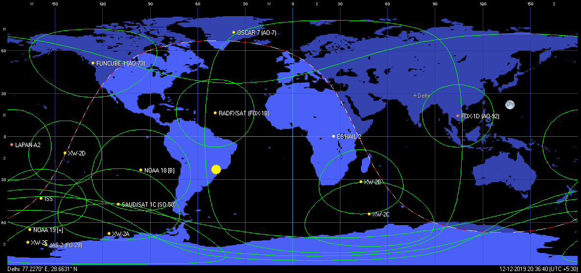
A screen grab of typical satellite pass projections made by a software utility.
We will examine some of the most popular earth satellite orbit prediction software in a separate article. Meanwhile, I leave you with a typical image grab above from one of them.


(26 votes, Rating: 5.00) - Please vote the article with your valuable star rating. Thanks! Basu (VU2NSB)


SSN SSNf(10.7) – Real-time Solar Data


